Involvement of Remote Sensing and GIS in Sustainable Groundwater Monitoring: An Overview
- 1. Survey Engineer, Independent researcher, Greece
Abstract
Advancements in remote sensing and Geographic Information Systems (GIS) have significantly enhanced the capabilities for sustainable groundwater monitoring. This paper researches recent developments, focusing on applications, challenges, and future directions. Key applications include groundwater level monitoring through satellite gravimetry, Interferometric Synthetic Aperture Radar (InSAR), Laser Altimetry (LIDAR), water quality assessment via remote sensing spectroscopy, aquifer characterization using electromagnetic surveys, and recharge and discharge estimation supported by remote sensing data and GIS modeling. Despite these advancements, challenges such as data quality and resolution, integration of diverse data sources, technical and financial barriers, and environmental variability persist. Future directions emphasize enhanced spatial and temporal resolution, the integration of Machine Learning (ML), open data initiatives, advanced sensor technologies, and the incorporation of sustainable practices and policies. These advancements promise to further revolutionize groundwater monitoring, enabling more effective and sustainable water resource management.
Keywords
• GIS
• Groundwater monitoring
• Hydrology
• Remote sensing
• Water management
• Water sustainability
CITATION
Kofidou M (2024) Involvement of Remote Sensing and GIS in Sustainable Groundwater Monitoring: An Overview. JSM Environ Sci Ecol 12(2): 1097.
INTRODUCTION
Sustainable groundwater management is increasingly crucial as global water demands rise and aquifer depletion accelerates [1]. Remote sensing and GIS have emerged as powerful tools for monitoring groundwater resources due to their ability to provide spatially comprehensive and temporally frequent data [2]. Groundwater, a vital source of freshwater for agriculture, industry, and domestic use, faces mounting pressures from population growth, climate change, and unsustainable extraction practices [1,3]. Traditional groundwater monitoring methods often rely on sporadic well measurements, which sometimes not capture spatial variability or long-term trends effectively [4,5]. Furthermore, although traditional groundwater monitoring methods are conventional and quite effective methods, they often present limitations and challenges that prevent management and comprehensive understanding [5,6].
In contrast, remote sensing technologies offer the ability to observe large-scale changes in groundwater storage, water quality, and hydrological processes over extensive areas and time frames [5,7,8]. Remote sensing applications in groundwater monitoring include satellite gravimetry for detecting changes in groundwater storage, InSAR for measuring land subsidence due to groundwater extraction, and remote sensing spectroscopy for assessing water quality parameters like turbidity and contamination. GIS complements these capabilities by integrating diverse data sources, facilitating spatial analysis, enabling integration and visualization of spatial data and supporting decision-making processes related to groundwater management [5,9,10].
Despite these advancements, several challenges remain. These include ensuring data quality and resolution suitable for groundwater monitoring, integrating data from different sensors and platforms, overcoming technical and financial barriers to access advanced technologies, and accounting for environmental and climatic variability that influence groundwater dynamics [3,5,11].
Looking ahead, future directions in remote sensing and GIS for sustainable groundwater monitoring include enhancing spatial and temporal resolution of satellite data, integrating ML for data analysis and modeling, promoting open data initiatives for improved data sharing and collaboration, developing advanced sensor technologies for enhanced monitoring capabilities, and incorporating sustainable practices and policies based on insights from remote sensing and GIS analyses [12].
The current study explores recent advancements in remote sensing and GIS technologies and their applications in sustainable groundwater monitoring, discusses the challenges associated with their implementation, and outlines future directions for research and development in this critical field. This paper aims to delve deeper into these topics, exploring the latest advancements, identifying persistent challenges, and proposing innovative approaches to enhance further the effectiveness and sustainability of groundwater monitoring efforts globally.
MATERIALS AND METHODS
Traditional Methods of groundwater monitoring, advantages and limitations
Traditional groundwater monitoring methods typically involve direct measurements and sampling at specific wells or bore holes [11,13]. These methods are foundational in understanding local groundwater dynamics and quality but may lack spatial coverage and temporal resolution compared to modern remote sensing and GIS approaches [5,14]. In table 1,
Table 1: Traditional methods along with their applications on groundwater monitoring
|
Method |
Applications |
References |
|
Well Monitoring |
Water Level Measurements, Water Quality Sampling |
[15,16] |
|
Pumping Tests |
Aquifer Properties |
[17,18] |
|
Piezometers |
Groundwater Pressure Monitoring |
[19,20] |
|
Water Chemistry Analysis |
Laboratory Analysis |
[21,22] |
|
Field Observations |
Visual Inspections |
[23] |
there are presented traditional methods along with their applications on groundwater monitoring.
Among the advantages of traditional methods of groundwater monitoring are the accuracy and reliability (i.e., direct measurements provide accurate data on groundwater levels and quality parameters), the site-specific (i.e., the traditional methods allow detailed monitoring at specific locations, providing insights into local groundwater conditions) and the established techniques (i.e., well monitoring and pumping tests have been refined over decades, making them well-understood and reliable methods) [24,25].
However, there are a lot of limitations in traditional methods of groundwater monitoring, such as the limited spatial coverage. For instance, traditional methods are often limited to specific wells or boreholes, providing point measurements that some times not represent broader aquifer conditions. Moreover, among their limitations is time-consuming, because regular monitoring and sampling require significant time and effort, particularly for widespread monitoring networks. Temporal resolution is another crucial limitation because data collection intervals might be infrequent compared to continuous monitoring provided by remote sensing technologies [8,26–28].
Remote Sensing methods in groundwater monitoring and their advantages
Remote sensing methods have transformed groundwater monitoring by offering several distinct advantages over traditional techniques. Remote sensing methods offer a range of advantages in groundwater monitoring, including global coverage, high spatial and temporal resolution, non-invasive data collection, and the ability to monitor diverse parameters relevant to ground water quantity and quality. These methods complement traditional monitoring approaches by providing comprehensive, continuous, and spatially extensive data, thereby enhancing our understanding and management of groundwater resources sustainably [5,29]. In table 2, remote sensing methods used in groundwater monitoring and their respective advantages are presented.
Table 2: Remote sensing methods used in groundwater monitoring and their respective advantages.
|
Method |
Advantages |
References |
|
Satellite Gravimetry |
Global Coverage: Provides measurements of changes in Earth's gravity field, indicating variations in groundwater storage over large regions. Long-Term Monitoring: Allows for continuous monitoring over years to detect trends in groundwater depletion or replenishment. Non-Invasive: Does not require direct physical access to the groundwater source, making it suitable for remote and inaccessible areas. |
[7,30-33] |
|
InSAR |
High Spatial Resolution: Can detect ground surface deformation at a millimeter to centimeter scale, identifying areas affected by land subsidence due to groundwater extraction. Wide Coverage: Covers large areas with each satellite pass, facilitating regional-scale monitoring. All-Weather Capability: Works in all weather conditions, allowing for continuous monitoring regardless of cloud cover. |
[34-38] |
|
Multispectral and Hyperspectral Remote Sensing |
Water Quality Assessment: Provides information on water quality parameters such as turbidity, chlorophyll concentration, and sediment levels through spectral signatures. Detection of Contamination: Can detect and monitor potential contaminants in groundwater sources, aiding in early detection and mitigation efforts. Detailed Land Use Mapping: Facilitates mapping of land cover and land use changes that impact groundwater recharge and quality. |
[5,39,40] |
|
Thermal Infrared Imaging |
Monitoring Groundwater Discharge: Detects groundwater discharge zones by identifying temperature anomalies on the land surface. Seasonal Variations: Captures seasonal variations in groundwater discharge rates based on temperature differences. Integration with Hydrological Models: Helps calibrate and validate hydrological models by providing surface temperature data related to groundwater interactions. |
[41-43] |
|
LIDAR |
High-Resolution Topographic Mapping: Provides detailed elevation data, facilitating the delineation of groundwater recharge and discharge areas. Surface Water-Groundwater Interactions: Helps in understanding surface water-groundwater interactions by mapping surface features and hydrological connectivity. Infrastructure Monitoring: Detects changes in infrastructure related to groundwater levels and land subsidence. |
[44,45] |
|
Electromagnetic Induction |
Aquifer Characterization: Measures subsurface electrical conductivity variations to map aquifer boundaries and identify saline intrusion zones. Non-Destructive: Provides data without the need for invasive drilling or excavation, minimizing disturbance to the environment. Rapid Surveys: Allows for quick surveys over large areas, providing efficient data collection for groundwater management purposes. |
[46,47] |
GIS methods in groundwater monitoring and their advantages
GIS plays a crucial role in groundwater monitoring by integrating spatial data, facilitating analysis, and aiding decision- making processes. GIS applications in groundwater monitoring offer significant advantages by providing spatial analysis capabilities, supporting modeling and simulation of groundwater processes, integrating diverse datasets, helping in decision- making through Decision Support Systems (DSS), and optimizing monitoring network designs. These capabilities contribute to more effective and sustainable management of groundwater resources, ensuring their availability for future generations while minimizing environmental impacts. As technology advances, GIS continues to play a pivotal role in advancing the understanding and management of groundwater systems worldwide. Table 3, indicates GIS applications in groundwater monitoring as well as their advantages.
Table 3: GIS applications in groundwater monitoring and their advantages.
|
Method |
Advantages |
References |
|
Spatial Analysis and Mapping |
Visualization: GIS allows for the visualization of groundwater data such as water levels, quality parameters, and hydrogeological features on maps. This visual representation helps in identifying spatial patterns, trends, and anomalies. Overlay Analysis: Enables the overlay of various spatial datasets (e.g., land use, geology, taopography) to assess their impact on groundwater resources. This integration provides a comprehensive understanding of groundwater dynamics. Zoning and Classification: Facilitates the delineation of groundwater vulnerability zones, recharge areas, and protection zones based on spatial analysis and modeling. |
[48-50] |
|
Modeling and Simulation |
Hydrogeological Modeling: GIS-based hydrogeological models simulate groundwater flow, recharge rates, and contaminant transport. These models help predict future groundwater conditions under different scenarios, supporting long-term planning and management strategies. Scenario Analysis: Allows for scenario testing and sensitivity analysis to evaluate the potential impacts of land use changes, climate variability, and groundwater extraction policies on aquifer sustainability. Risk Assessment: Integrates spatial data to assess risks associated with groundwater contamination, land subsidence, and infrastructure impacts, aiding in risk mitigation and emergency response planning. |
[51,52] |
|
Data Integration and Management |
Centralized Data Repository: GIS serves as a centralized platform for storing, managing, and querying diverse groundwaterrelated datasets, including monitoring well locations, water quality samples, and historical data. Data Interoperability: Facilitates the integration of data from various sources and formats (e.g., remote sensing, field measurements, historical records) into a unified spatial framework, ensuring data consistency and accessibility. Real-Time Monitoring: Supports real-time data acquisition from monitoring networks, allowing for immediate updates and analysis of groundwater conditions. |
[53,54] |
|
DSS |
Informed Decision-Making: GIS-based DSS provide tools and visualizations that help stakeholders, policymakers, and water resource managers make informed decisions about groundwater management strategies and regulatory actions. Public Engagement: Enhances public participation by visualizing complex groundwater data in user-friendly formats, promoting transparency and community awareness of groundwater issues. Compliance Monitoring: Supports compliance monitoring with regulatory standards and guidelines by spatially mapping groundwater quality trends and identifying areas requiring remedial actions. |
[55,56] |
|
Monitoring Network Design and Optimization |
Optimized Site Selection: GIS tools aid in designing optimal locations for monitoring wells and piezometers based on hydrogeological characteristics, ensuring representative data collection across the study area. Network Expansion: Facilitates the expansion and optimization of monitoring networks as new data becomes available or environmental conditions change, enhancing the efficiency of groundwater monitoring efforts. |
[51,57] |
CHALLENGES AND LIMITATIONS USING REMOTE SENSING AND GIS IN GROUNDWATER MONITORING
Remote sensing and GIS offer powerful tools for groundwater monitoring, but they also face several challenges and limitations that need to be addressed [5,29].
Some of the challenges resulting from the use of remote sensing and GIS methods in groundwater monitoring is the spatial and temporal resolution, because remote sensing data might not have the required spatial resolution to accurately monitor small scale changes in groundwater levels or quality or the demanded temporal resolution, which is also limited, affecting the ability to capture rapid changes in groundwater dynamics [7,29]. Moreover, regarding the depth of investigation, several remote sensing techniques are limited in ability to observe groundwater because they primarily sense surface features directly. This fact restricts their usefulness in areas with deep aquifers or where groundwater is not directly influenced by surface conditions [58]. Additionally, optical remote sensing methods (e.g.,satellite imagery) are affected by cloud cover, which limits data availability, especially in regions prone to frequent cloud cover [59]. Cost and accessibility are other challenges, because high- resolution remote sensing data and GIS software are expensive, limiting accessed by researchers and organizations, especially in developing regions. Furthermore, integrating remote sensing data with ground-based measurements (e.g., well data, in-situ data) and validating results could be challenging due to differences in spatial scales and data formats. Finally, remote sensing and GIS data often demand complex processing techniques (e.g., image classification, spatial analysis) that require specialized skills and computational resources [8].
Accordingly, among the limitations in remote sensing and GIS for groundwater monitoring, is the fact that remote sensing techniques typically measure surface indicators related to groundwater, such as soil moisture or land surface elevation changes, rather than directly measuring groundwater levels or quality [7,30]. Moreover, monitoring groundwater quality parameters (e.g., contamination levels) through remote sensing alone is challenging due to the indirect nature of most remote sensing measurements. The vegetation and land cover can interfere with remote sensing signals, making it difficult to accurately interpret data in vegetated or urban areas. Another limitation is the fact that the scale of remote sensing data may not always match the scale of groundwater processes and management needs, leading to challenges in applying remote sensing information effectively. In conclusion, regulatory frameworks and policies may not always incorporate remote sensing data into groundwater management strategies, limiting its practical application [1,5].
GROUNDWATER MONITORING: DATA PROCESSING AND MODELING
Data processing and modeling are essential components of groundwater monitoring, involving the transformation of raw data into meaningful information and the development of predictive models to understand groundwater dynamics. Effective data processing and modeling in groundwater monitoring are critical for understanding complex hydrogeological systems, predicting future groundwater conditions, and developing sustainable management strategies. Advances in technology, including remote sensing, GIS, and ML, continue to enhance the ability to monitor and manage groundwater resources efficiently and ensure their long-term sustainability amid changing environmental conditions [8,52]. An overview of data processing and modeling techniques used in groundwater monitoring is described in the sections below. Moreover, a flowchart is provided to make the whole procedure more comprehensive and concise (Figure 1).
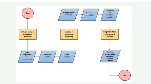
Figure 1: Flowchart of data processing and modeling in groundwater monitoring.
Data processing in groundwater monitoring
Data acquisition and preprocessing: This step includes data sourcing. Data sourcing is a process that includes data from monitoring wells, piezometers, remote sensing (e.g., satellite imagery, InSAR), and meteorological stations. After data sourcing, another process follows which has to do with quality control. In this process, data accuracy and reliability through calibration, validation, and outlier detection are ensured. Spatial integration is the remaining process of data acquisition and preprocessing, in which data from diverse sources are merged into a unified spatial framework for consistent analysis using GIS [14].
Time-Series analysis: After data acquisition and preprocessing, time-series analysis follows in which temporal trends and seasonal patterns participate. In temporal trends, variations in groundwater levels, quality parameters, and hydrological conditions over time are analyzed, while in seasonal trends recurring patterns such as annual fluctuations, drought cycles, and impacts of precipitation events are identified [60].
Spatial analysis: Regarding data acquisition and preprocessing, spatial analysis is the last step, in which Spatial Interpolation Techniques (SIT) (i.e., kriging, inverse distance weighting) are used to estimate values between monitoring points, creating continuous surfaces of groundwater levels or quality parameters. In the following procedure, namely hotspot detection, spatial clusters of high or low groundwater levels, contamination plumes, or areas susceptible to land subsidence are identified [5,28].
Modeling in groundwater monitoring
Hydrogeological modeling: In hydrogeological modeling, conceptual models are first taken into account, where the physical characteristics and processes of the aquifer system, including boundaries, recharge areas, and hydraulic properties are represented [14,52]. Afterward, numerical models (i.e., MODFLOW, FEFLOW, and MT3DMS), are used to simulate groundwater flow, contaminant transport, and interactions with surface water [14,24]. Finally, steady-state and transient simulations occur, where groundwater conditions under steady- state (long-term equilibrium) and transient (time-varying) conditions to assess aquifer response to pumping, recharge, and climatic variability are simulated [14,42].
Data-driven approaches: Data-driven approaches such as ML and Statistical Analysis (SA) occur. ML applies algorithms to learn patterns from historical data and make predictions. Techniques such as neural networks, random forests, and support vector machines can be used for groundwater level forecasting, water quality prediction, and anomaly detection, while SA utilizes statistical methods (e.g., regression analysis, time series analysis) to analyze relationships between groundwater variables and environmental factors [5,11].
Uncertainty and sensitivity analysis: In this process, the reliability of model predictions by assessing uncertainties in input parameters, boundary conditions, and model structure is evaluated via the uncertainty quantification procedure. Moreover, key factors influencing model outcomes and guiding decisions on parameter prioritization and data collection efforts are identified via sensitivity analysis procedure [8,42,60].
Integration of data processing and modeling
Integration of data processing and modeling includes processes such as iterative process which combines data processing with modeling to refine model inputs and validate outputs against observed data, model calibration which adjusts model parameters to match observed groundwater behavior and improve model accuracy and scenario analysis which uses models to explore alternative management scenarios, evaluate impacts of land use changes or climate scenarios on groundwater resources, and support decision-making processes [5,54].
OVERCOMING CHALLENGES
To overcome the challenges and limitations of the use of remote sensing and GIS methods in groundwater monitoring, researchers should integrate multiple data sources. For instance, combining remote sensing data with ground- based measurements and modeling could provide a more comprehensive understanding of groundwater dynamics. Concerning advancements in technology, improved sensors and data processing techniques, are continuously expanding the capabilities for groundwater monitoring. Moreover, building technical capacity among stakeholders to effectively use remote sensing and GIS tools for groundwater management is crucial for overcoming skill-related limitations. Accordingly, developing policies that integrate remote sensing data into groundwater management frameworks can help overcome regulatory challenges. In summary, while remote sensing and GIS offer significant potential for groundwater monitoring, addressing their inherent challenges and limitations requires a multidisciplinary approach involving technology development, policy support, and capacity building.
FUTURE CHALLENGES AND RECOMMENDATIONS
A challenge, that scientists should take into consideration is next-generation sensors. For example, the development of compact, cost-effective sensors for specific groundwater parameters (e.g., contaminants, isotopes) to improve monitoring capabilities should be a priority. Additionally, artificial- intelligence insights, such as the use of predictive analytics and ML algorithms to forecast ground water trends and anticipate future challenges, should be studied. Finally, continued efforts to incorporateremotesensingand GIStechnologiesintogroundwater management policies and regulations for sustainable resource use are essential. Overall, these emerging technologies and trends are reshaping the landscape of groundwater monitoring, offering innovative solutions to address existing challenges and advance sustainable water management practices. Continued research and collaboration are essential to harnessing the full potential of remote sensing and GIS in safeguarding groundwater resources for future generations.
DISCUSSION AND CONCLUSIONS
This article discusses innovative applications of remote sensing and GIS technologies in groundwater monitoring. Remote sensing and GIS play a key role in overcoming the limitations of traditional groundwater monitoring. Remote sensing technologies, suchassatellite imagery, InSAR, and thermal infrared imaging, enable the collection of extensive data over large and often inaccessible areas. This capability allows comprehensive monitoring of groundwater resources, identifying changes in groundwater levels, land subsidence, and contamination spread.
Moreover, the high-resolution data provided by remote sensing methods permits detailed spatial analysis, identifying small-scale variations and trends in groundwater levels and quality. Temporal data helps in understanding seasonal variations and long-term trends, essential for sustainable groundwater management. Additionally, remote sensing methods are non-invasive, reducing the environmental impact and costs associated with traditional groundwater monitoring methods. This non-invasive nature is particularly advantageous for monitoring groundwater in remote or ecologically sensitive areas. GIS, acts as a powerful platform for integrating diverse datasets, including remote sensing data, field observations, and historical records. This integration facilitates comprehensive spatial analysis, enabling the visualization of groundwater data on maps, overlay analysis, and the delineation of vulnerability and recharge zones.
The combination of remote sensing and GIS enhances analytical capabilities, such as hotspot detection, spatial interpolation, and hydrogeological modeling. These analyses provide valuable insights into groundwater dynamics, contamination sources, and the impacts of land use changes and climatic variability. DSS leverage remote sensing data to support informed decision-making. They provide tools and visualizations that help stakeholders and policymakers develop effective groundwater management strategies, ensuring the sustainable use of this critical resource. Despite their advantages, remote sensing and GIS face challenges such as data resolution limitations, cloud cover interference, and high costs of high-resolution imagery and software. Additionally, integrating remote sensing data with ground-based measurements and validating results could be a complex procedure requiring specialized skills. In this paper, prospects and recommendations are highlighted, i.e., advances in remote sensing technology, ML, and data processing are expected to further enhance the capabilities of groundwater monitoring systems. Additionally, improved resolution, real-time data acquisition, and more sophisticated analytical tools would enable more accurate and efficient groundwater management. In conclusion, the integration of remote sensing and GIS in groundwater monitoring represents a significant advancement in the sustainable management of groundwater resources. By providing detailed, accurate, and timely data, these technologies support the development of effective strategies to preserve groundwater quality and availability for future generations. Addressing the current limitations and challenges will further enhance their role in achieving sustainable groundwater management goals.
FUNDING
This research received no external funding.
CONFLICTS OF INTEREST
The authors declare no conflicts of interest.
REFERENCES
- Gleeson T, Alley WM, Allen DM, Sophocleous MA, Zhou Y, Taniguchi M, et al. Towards sustainable groundwater use: Setting long-term goals, backcasting, and managing adaptively. Ground Water. 2012; 50: 19-26.
- Homer C, Dewitz J, Jin S, Xian G, Costello C, Danielson P, et al. Conterminous United States land cover change patterns 2001–2016 from the 2016 national land cover database. ISPRS J Photogramm Remote Sens. 2020; 162: 184-199.
- Famiglietti JS. The global groundwater crisis. Nat Clim Chang. 2014; 4: 945-948.
- Alley WM, Konikow LF. Bringing GRACE Down to Earth. Groundwater. 2015; 53: 826-829.
- Shaikh M, Birajdar F. Advancements in remote sensing and GIS for sustainable groundwater monitoring: Applications, challenges, and future directions. Int J Res Eng Sci Manag. 2024; 7: 16-24.
- Shlomi S, Ostfeld A, Rubin H, Shoemaker C. Optimal groundwater contamination monitoring using pumping wells. Water Sci Technol. 2010; 62: 556-569.
- Rodell M, Velicogna I, Famiglietti JS. Satellite-based estimates of groundwater depletion in India. Nature. 2009; 460: 999-1002.
- Elbeih SF. An overview of integrated remote sensing and GIS for groundwater mapping in Egypt. Ain Shams Eng J. 2015; 6: 1-15.
- Chowdhury A, Jha M, Machiwal D. Application of remote sensing and GIS in groundwater studies: An overview. 2003.
- Shaikh M, Birajdar F. GIS-based multi-criteria evaluation techniques for demarcation of solid waste disposal site locations in solapur city, Maharashtra, India. IJNRD. 2023; 8: 516-523.
- Taylor RG, Scanlon B, Döll P, Rodell M, van Beek R, Longuevergne L, et al. Groundwater and climate change: Recent advances and a look forward. Nat Clim Chang. 2013; 3: 322-329.
- Richey AS, Thomas BF, Lo MH, Reager JT, Famiglietti JS, Voss K, et al. Quantifying renewable groundwater stress with GRACE. Water Resour Res. 2015; 51: 5217-5238.
- Alley WM, Healy RW, LaBaugh JW, Reilly TE. Flow and storage in groundwater systems. Science. 2002; 296: 1985-1990.
- Sophocleous, M. Interactions between groundwater and surface water: The state of the science. Hydrogeol J. 2002; 10: 52-67.
- Granato G, Smith K. Automated ground-water monitoring with Robowell--case studies and potential applications. Proc SPIE - Int Soc Opt Eng. 2002; 4575.
- Qin R, Cao G, Wu Y, Zhang C, Zengguang X. A method for selecting monitoring wells and measured water-quality characteristics with application to the Liaohe River (China) groundwater system. Environ Earth Sci. 2016; 75: 1-15.
- Suprapti A, Pongmanda S. Estimation of aquifer parameters using pumping tests: Case study of hotel Makassar paradise. IOP Conf Ser Earth Environ Sci. 2020; 419: 012118.
- Sikdar P. Pumping test for aquifers: Analysis and evaluation: Issues and challenges in South Asia. 2019; 267-277.
- Rosenberry D, LaBaugh J, Hunt R. Use of monitoring wells, portable piezometers, and seepage meters to quantify flow between surface water and ground water. 2008.
- Powers J, Corwin A, Schmall P, Kaeck W. Piezometers for Groundwater Measurement and Monitoring. 2007; 111-120.
- Rice EW, Baird RB, Eaton AD. Standard Methods for the Examination of Water and Wastewater. 23rd edition APHA/AWWA/WEF. 2017.
- Zanella, R. Water Chemical Analysis. Brazilian J Anal Chem. 2018; 5: 1-2.
- Harvey CF, Swartz CH, Badruzzaman AB, Keon-Blute N, Yu W, Ali MA, et al. Arsenic mobility and groundwater extraction in Bangladesh. Science. 2002; 298: 1602-1606.
- Masood A, Atiq M, Rahman U, Zia M, Rahman U, Waseem M, et al. An Overview of Groundwater Monitoring through Point-to Satellite- Based Techniques. Water. 2022; 14: 565.
- Fan Y, Wang X, Funk T, Rashid I, Herman B, Bompoti N, et al. A critical review for real-time continuous soil monitoring: Advantages, challenges, and perspectives. Environ Sci Technol. 2022; 56: 13546-13564.
- Bear J, Cheng AHD. Modeling Groundwater Flow and Contaminant Transport. 2nd edition. Netherlands. Springer. 2010.
- Sani S, Ibrahim A, Musa A, Dahiru M, Baballe M. Drawbacks of traditional environmental monitoring systems. Comput Inf Sci 2023; 16: 30.
- Ruybal CJ, Hogue TS, McCray JE. Evaluation of groundwater levels in the arapahoe aquifer using spatiotemporal regression kriging. Water Resour Res. 2019; 55: 2820-2837.
- Schmugge T, Kustas W, Ritchie J, Jackson T, Rango A. Remote Sensing in Hydrology. Adv Water Resour. 2002; 25: 1367-1385.
- Famiglietti JS, Lo M, Ho SL, Bethune J, Anderson KJ, Syed TH, et al. Satellites measure recent rates of groundwater depletion in California’s Central Valley. Geophys Res Lett. 2011; 38: 2-5.
- Scanlon BR, Longuevergne L, Long D. Ground referencing GRACE satellite estimates of groundwater storage changes in the California Central Valley, USA. Water Resour Res. 2012; 48: 1-9.
- Tapley BD, Bettadpur S, Watkins M, Reigber C. The gravity recovery and climate experiment: Mission overview and early results. Geophys Res Lett. 2004; 31: 1-4.
- Wahr J, Swenson S, Zlotnicki V, Velicogna I. Time-variable gravity from GRACE: First results. Geophys Res Lett. 2004; 31.
- Ferretti A, Prati C, Rocca F. Permanent scatterers in SAR interferometry. IEEE Trans Geosci Remote Sens. 2001; 39: 8-20.
- Galloway DL, Burbey TJ, Review: Regional land subsidence accompanying groundwater extraction. Hydrogeol J. 2011; 19: 1459-1486.
- Tomás R, Márquez Y, Lopez-Sanchez JM, Delgado J, Blanco P, Mallorqui JJ, et al. Mapping ground subsidence induced by aquifer overexploitation using advanced differential SAR interferometry: Vega media of the segura river (SE Spain) case study. Remote Sens Environ. 2005; 98: 269-283.
- Lanari R, Casu F, Manzo M, Zeni G, Berardino P, Manunta M, et al. An overview of the small BAseline subset algorithm: A DInSAR technique for surface deformation analysis. Pure Appl Geophys. 2007; 164: 637- 661.
- 38. Massonnet D, Feigl KL. Radar interferometry and its application to changes in the earth’s surface. Rev Geophys. 1998; 36: 441-500.
- Kumar S. Remote sensing for land resource monitoring and management. 2018; 355-375.
- Miller J, Kullar S, Cochrane D, Nixon O, Lomako A, Draijer C. Hyperspectral and multispectral sensors for remote sensing. Proc SPIE - Int Soc Opt Eng. 2010; 7857.
- Schuetz T, Weiler M. Quantification of localized groundwater inflow into streams using ground-based infrared thermography. Geophys Res Lett. 2011; 38: 1-5.
- Loheide SP 2nd, Gorelick SM. Quantifying stream-aquifer interactions through the analysis of remotely sensed thermographic profiles and in situ temperature histories. Environ Sci Technol. 2006; 40: 3336- 3341.
- Pfister L, McDonnell J.J, Hissler C Hoffmann L. Ground-based thermal imagery as a simple, practical tool for mapping saturated area connectivity and dynamics Hydrol Process. 2010; 24: 3123-3132.
- Hladik C, Alber M. Accuracy assessment and correction of a LIDAR- derived salt marsh digital elevation model. Remote Sens Environ. 2012; 121: 224-235.
- Hoffmann J, Zebker HA, Galloway DL, Amelung F. Seasonal subsidence and rebound in Las Vegas Valley, Nevada, observed by synthetic aperture radar interferometry. Water Resour Res. 2001; 37: 1551-1566.
- Fitterman DV, Stewart MT. Transient electromagnetic sounding for groundwater. Geophysics 1986; 51, 995-1005.
- McNeill JD. 7. Use of Electromagnetic Methods for Groundwater Studies. In Geotechnical and Environmental Geophysics: Volume I, Review and Tutorial. 1990; 191-218.
- Jha MK, Chowdary VM, Chowdhury A. Groundwater assessment in salboni block, West Bengal (India) using remote sensing, geographical information system and multi-criteria decision analysis techniques. Hydrogeol J. 2010; 18: 1713-1728.
- Machiwal D, Jha MK, Mal BC. Assessment of groundwater potential in a semi-arid region of India using remote sensing, GIS and MCDM techniques. Water Resour Manag. 2011; 25: 1359-1386.
- Babiker IS, Mohamed MAA, Hiyama T, Kato K. A GIS-based DRASTIC model for assessing aquifer vulnerability in Kakamigahara heights, gifu prefecture, central Japan. Sci Total Environ. 2005; 345: 127-140.
- Chowdhury A, Jha MK, Chowdary VM, Mal BC. Integrated remote sensing and GIS-based approach for assessing groundwater potential in West Medinipur district, West Bengal, India. Int J Remote Sens. 2008; 30: 231-250.
- Anderson MP, Woessner WW, Hunt RJ. Applied Groundwater Modeling: Simulation of Flow and Advective Transport. 2015.
- Walker JP, Houser PR. Requirements of a global near-surface soil moisture satellite mission: Accuracy, repeat time, and spatial resolution. Adv Water Resour. 2004; 27: 785-801.
- Goodall JL, Robinson BF, Castronova AM. Modeling water resource systems using a service-oriented computing paradigm. Environ Model Softw. 2011; 26: 573-582.
- Laniak GF, Olchin G, Goodall J, Voinov A, Hill M, Glynn P, et al. Integrated environmental modeling: A vision and roadmap for the future. Environ Model Softw. 2013; 39:3-23.
- Borowski I, Hare M. Exploring the gap between water managers and researchers: Difficulties of model-based tools to support practical water management. Water Resour Manag. 2007; 21: 1049-1074.
- Cuffney TF, Bilger MD, Haigler AM. Ambiguous taxa: Effects on the characterization and interpretation of invertebrate assemblages. J North Am Benthol Soc. 2007; 26: 286-307.
- Engman ET. Remote sensing in hydrology. Geophys Monogr Ser. 2002; 108: 165-177.
- Vermote E, Saleous, NZ, Justice CO. Atmospheric correction of MODIS data in the visible to middle infrared. Remote Sens Environ. 2002; 83: 97-111.
- Stoll S, Hendricks Franssen HJ, Butts M, Kinzelbach W. Analysis of the impact of climate change on groundwater related hydrological fluxes: A multi-model approach including different downscaling methods. Hydrol. Earth Syst Sci. 2011; 15: 21-38.


